Inundation
noun: inundation; plural noun: inundations
1. an overwhelming abundance of people or things.
2. flooding.
The plague of disinformation
We live in a world filled with ever-increasing amounts of dis-information. There are times when the inability to access crucial, accurate, and most-relevant information in a timely manner can damage more than just our attention spans. Information is empowering and the difference in available information now versus 10 years ago is incredible.
That being said, news from the media is generally not informative information and should be considered more dangerous than the storm itself. A hurricane can rip apart a house but the mainstream media in America seems to want to rip apart the fabric of society. Anyone sticking it out in S Florida not only has the right to do so they also know the difference between NOAA/NHC and some fear mongering prime time news anchor.
Aid comes in many forms
I am no stranger to hurricanes and this is something I have written about previously. Nothing is worse than watching something terrible about to happen to our families while not being able to help. I realized that what I could do that would to help while still 2000 miles away was simple. Provide the most crucial and up-to-date data regarding the storm so the people on the receiving end didn't have to waste time or energy staying informed.
The information was relayed to my friends and family as a static html file served up by nginx from a over-specced cloud server. The goal was to deliver the most crucial information as fast as possible in a way that was easily viewable from even the oldest phone or slowest connection. Pageload time from NYC was 0.10ms and from Miami was .25ms meaning a 2g connection would still have quick access.
At the very bottom is the last version before shutdown of the DataBeam. The information sources will still be just as valuable the next time around and the pictures will attest to this value.
But first, let's take a look at the data which I consider to be the most crucial and the most informative.
Data
Live data from NPSF1 aka the Naples Pier. Open links into separate tabs and refresh as needed.
Inundation
https://tidesandcurrents.noaa.gov/waterlevels.html?id=8725110
Tide Predictions
https://tidesandcurrents.noaa.gov/noaatidepredictions.html?id=8725110
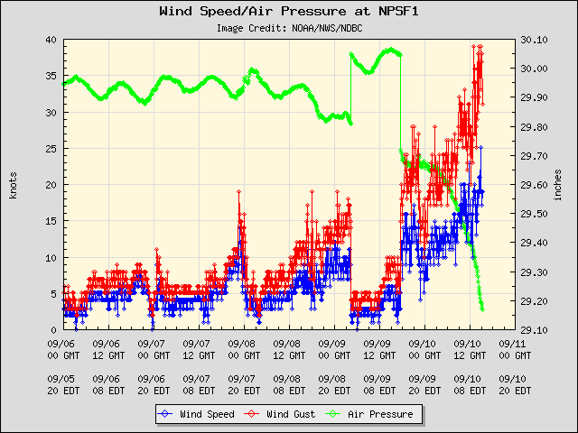
WindSpeed and Air Pressure
http://www.ndbc.noaa.gov/show_plot.php?station=npsf1&meas=wdpr&uom=E&time_diff=-4&time_label=EDT
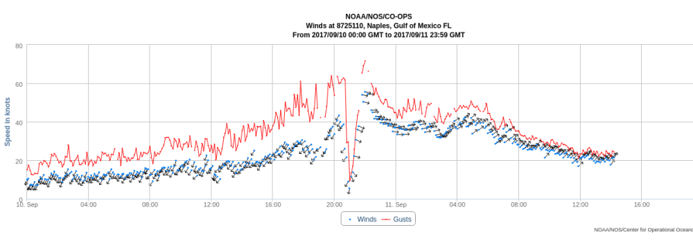
Windspeed and Direction with Gusts
https://tidesandcurrents.noaa.gov/met.html?id=8725110
Intensity Increasing
As of 11:50AM EST data for 26.132 N 81.807 W (26°7'54" N 81°48'27" W)
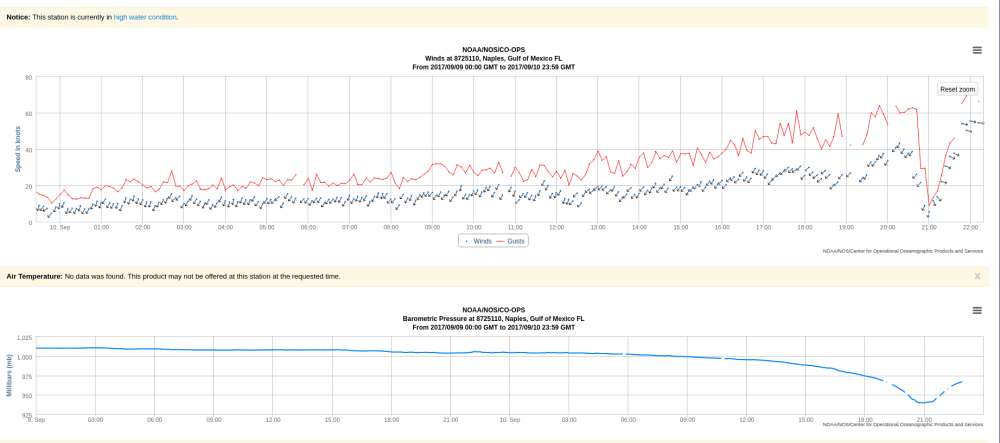
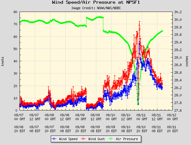
Winds Increasing + Pressure Plummeting
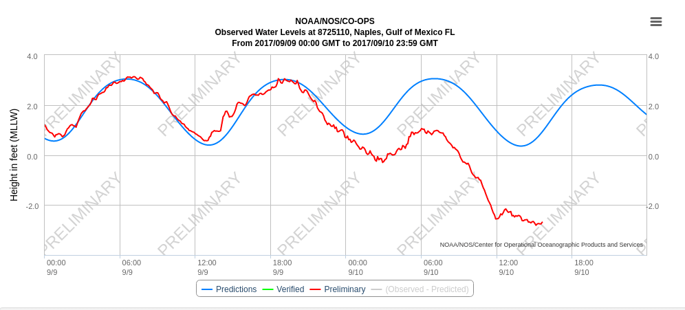
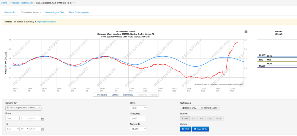
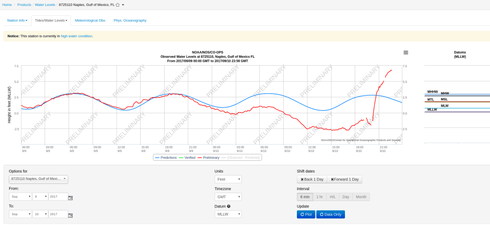
Water Levels Dropping
This is generally a bad sign and clear indicator that it is time to hunker down. Tides are a stationary process as are water levels which indicate that a mean reversion here is going to bring bad things.
The Eye of the Storm
Storm Surge
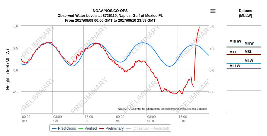
What goes out must come in. Just past the high tide mark.
Notice how the water levels dropped to -2.5 feet leading up the eye making landfall which brought the levels to close to +7.0 feet
This 10 feet of water is an example of why hurricanes cause so much damage. Wind and rain are damaging but storm surge is deadly.
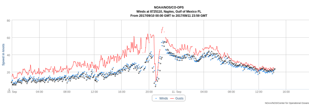
Wind Speed & Pressure Winds dropping from 60 knots to a light breeze. Pressure plummets to roughly 940mbar. This is the eye passing. 20 Minutes of an eerily calm intermission. Then begins the second act.
Plots
Incredible how the data itself shows the intensity as a measure of distance from the eye.
Update 11PM EST
NHC ADVISORY KEY DATA
- LOCATION...23.5N 81.0W
- ABOUT 30 MI...50 KM NNE OF VARADERO CUBA
- ABOUT 90 MI...145 KM SE OF KEY WEST FLORIDA
- MAXIMUM SUSTAINED WINDS...120 MPH...195 KM/H
- PRESENT MOVEMENT...NW OR 305 DEGREES AT 6 MPH...9 KM/H
- MINIMUM CENTRAL PRESSURE...933 MB...27.55 INCHES
- At 1100 PM EDT (0300 UTC), the eye of Hurricane Irma was located
near latitude 23.5 North, longitude 81.0 West. Irma is moving
slowly northwestward away from the north coast of Cuba near 6 mph
(9 km/h).
Irma's nearly 24-hour traversal of the north coast of Cuba appears
to have affected the hurricane's structure and intensity. Irma has stuttered near the north coast of Cuba for the past few
hours, which may be a harbinger of the north-northwestward turn
that we've been waiting for. Because of Irma's
hesitation to move northwestward, the new track guidance has shifted
ever so slightly westward, and the new NHC track is just a little
left of the previous one.
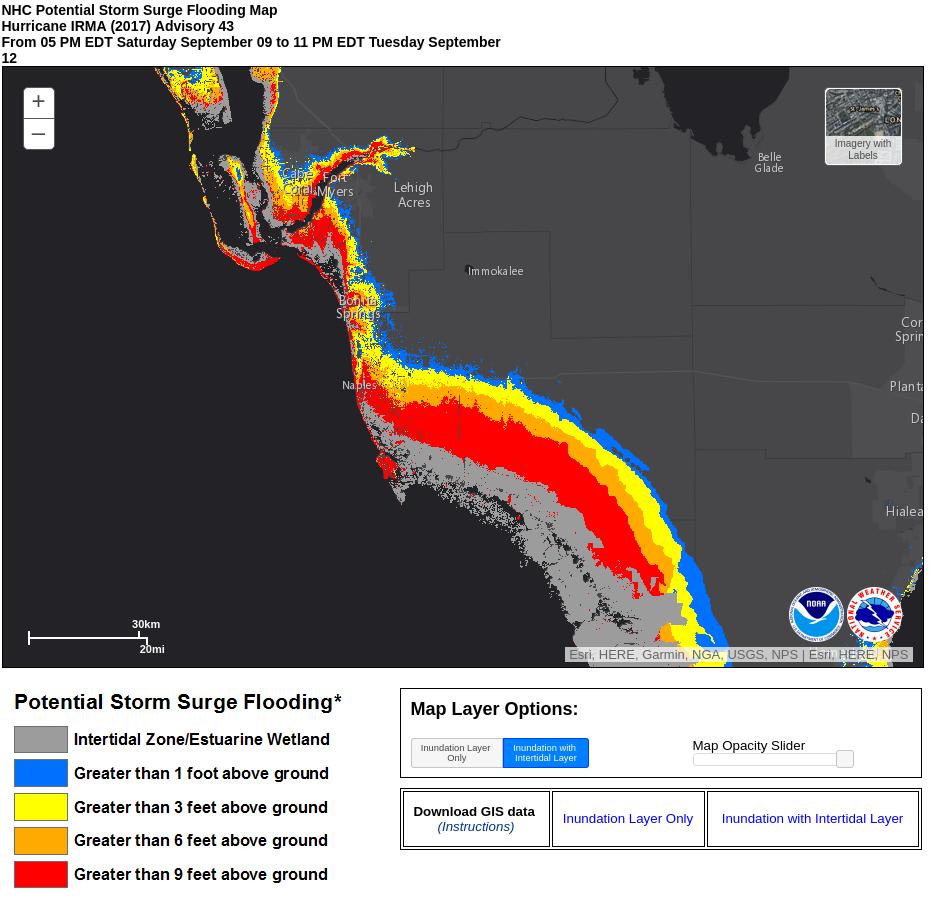
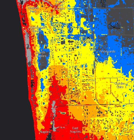
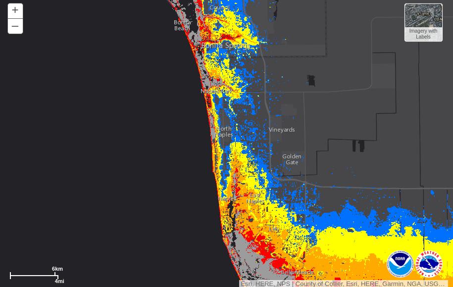
Storm Surge Inundation is still a major life-threatening concern for much of Naples and the surrounding area.
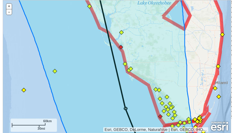
Pine Ridge living up to the name but this model is no guarantee of safety.
Current estimate have the eye on a slightly more Westward track with the eye passing Naples in the early afternoon. Current High Tide forecasts call for high tide ~4PM EST with the height of the tide lower than the mean at 3.0 feet. If the storm regains speed as it moves over the keys the probability of low tide during peak storm surge increases.
Overall, the latest report is leaning towards the good news end of the spectrum but the threat to life is still very real.
Buoy readings indicate heavier winds expected in Naples area within the next 90 minutes.
Outdated but Useful Data Sources
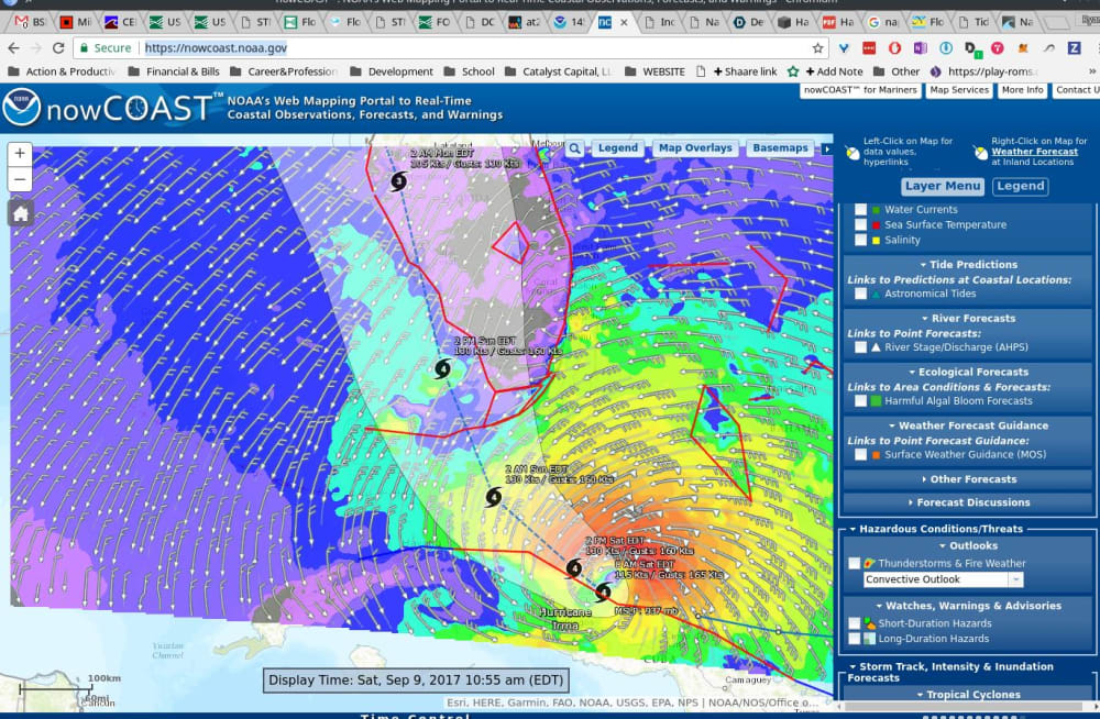
Note these will show the current data from the present. Historical screenshots can be found below.
Live Tide Forecast - Naples Pier
USGS Short Term Flood Sensors Collier County Area
Interactive Storm Surge Inundation Map if peak inundation at high tide
Live Interactive Map NOAA Mapping Coastal Observations
Top Gun
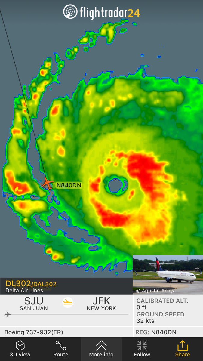
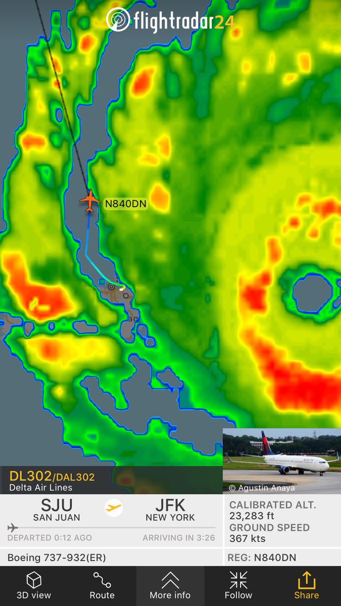
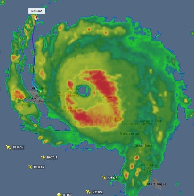
I'd like to take this moment to recognize and extend a sincere thank you to everyone working to ensure the safety of the countless people in the line of fire. The stories that you don't hear about are the ones that illustrate the amazing things we as humans are capable of when we put others first. How about the Delta pilot who flew the last plane out of PR between the outer bands of the storm (and of course the ground crew who made a 52 minute touch-down to take-off possible).
